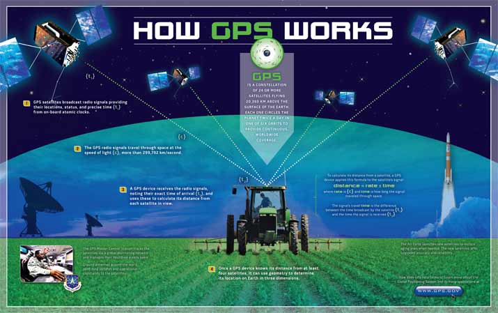
Lets start with how it works
So how is it related to conservation?
 |
| Endangered Monk seal with a GPS tracker |
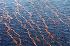 |
| GPS help crews respond to the Golf of Mexico oil spill in 2010 |
GPS and Wildlife - Whats the link?
GPS
has helped researchers investigate habitats, use of space, movement
patterns and selection of resources in wildlife providing data that
helps us better understand the world around us (Adams, Dickinson,
Robertson, Van Heezik, 2013). GPS collars can also help researchers
identify if endangered animals are entering dangerous areas where poachers or natural dangers exist or other options for habitats (NTV
Kenya, 2008).
One
of the greatest advantages of GPS in animal research is that it allows
information and data to become available without the influence of human
intersection (Pebsworth, Morgan, & Huffman, 2012). GPS devises are
attached to animals and contain their own power supply, data storage,
memory, wireless signals and transmit the data so humans do not have to
be present with the animals eliminating the possibility of inaccurate
research (Handcock, Swain, Bishop-Hurley, Patison,
Wark, Valencia & O'Neill, 2009).
GPS
can also be very helpful when used with other technology such as camera
traps or wireless sensor networks. One study used GPS trackers to
discover the best area to place camera traps to track a jaguar
population saving valuable time and resources (Soisalo & Cavalcanti,
2006).
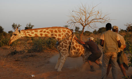 |
| West African giraffe fitted with a camouflaged GPS collar. |
A
great example of research efforts that have been used to help
endangers species is the West African giraffe that were fitted with GPS
collars in 2010. The data collect has been used to educate the public
about their home ranges, helped the conservation efforts of restoring
the population, and to help compensate locals for crop loss due to the
giraffe's travels and avoided unnecessary giraffe killings by locals (Vaughan,
2010).
The Olympics, Snow Leopards and GPS
As
the olympic games are upon us it's interesting to note that the link
between GPS technology and wildlife conservation can be easy connected
to the host country of Russia. Russia may have as few as 100 snow
leopards left in the Altay mountains – although it is far away from
town of Sochi (Snow Leopard Trust, 2014).
Snow
Leopards trust says it best "in order to protect wild snow leopards,
we first need to understand where they live" (Snow Leopard Trust,
2014). They participate in the GPS collar, long-term ecological study
in the South Gobi region of Mongolia. This study has allowed researchers
to track and look at the lives of 16 amazing big cats to help understand them and create strategies for conservation of the endangered species. They have also used
this research to assess the needs of the snow leopards, track home
ranges and educate the natives. The education component helps decrease poaching and
unnecessary killings of snow leopards.
If you are a big cat lover, like myself, this is an awesome use for this extraordinary technology. Visit their blog to learn more about Snow Leopards and the technology and research used to protect them.
 |
| A rare look at an endangered snow leopard |
The Downsides
Unfortunately,
with every piece of technology there are downsides and limitations. One
ongoing debate is the heath implications of using this
technology and what potential cell damage the signals can cause
(Heller, 2010).
Other limitations include the need for medicine to temporally put large
animals under to attach the GPS collars, the cost of the collar and
staff, the safety of the animals
when they are under and the time, money, and resources it can take, to trap and collar an animal
(NTV Kenya, 2008).
When collecting data samples with GPS trackers there
are no set standards as to what is an acceptable sampling interval. This
is an ongoing challenge for most researchers working with GPS trackers.
One would think the most amount of data or samples would be the best
and easiest option however, GPS trackers have a limited amount of
battery life and data storage space. The other concern is that as the
battery life starts to fade so does the accuracy of the readings causing
unusable data (Johnson & Ganskopp, 2008). The GPS trackers also
requires three of the 24 satellites to be lined up to produce accurate
data so data can be missed and valuable information can be lost if the
triangulation fails (Pebsworth, Morgan, & Huffman, 2012).
Think Global!
As
you can see GPS can be used for much more than just guiding you from
one place to the next. It is an essential tool for every day life.
Conservationist and researchers use GPS to help endangered species and
manage disasters that effect everyone. So the next time you turn on your
GPS think about all the amazing creatures the depend on GPS for
survival even more than you do!

References:
Air
Force Space Command. (2013, May 14). GPS Modernization Video - YouTube.
Retrieved February 17, 2014, from
http://www.youtube.com/watch?v=chNQW22vVNI#t=20
Handcock, R. N., Swain, D. L., Bishop-Hurley, G. J., Patison, K. P., Wark, T., Valencia, P., & ... O'Neill, C. J. (2009). Monitoring Animal Behavior and Environmental Interactions Using Wireless Sensor Networks, GPS Collars and Satellite Remote Sensing. Sensors (14248220), 9(5), 3586-3603. doi:10.3390/s90503586
Heller, P. B. (2010). Frankenstein's Monster: The Downsides of Technology. International Journal Of Technology, Knowledge & Society, 6(3), 121-132.
Johnson, D. D., & Ganskopp, D. C. (2008). GPS Collar Sampling Frequency: Effects on Measures of Resource Use. Rangeland Ecology & Management, 61(2), 226-231.
National Coordination Office for Space-Based Positioning, Navigation, and Timing. (2014, February 11). GPS.gov. GPS.gov. Government. Retrieved February 17, 2014, from http://www.gps.gov/systems/gps
NTV Kenya. (2008). KWS elephant collaring exercise: Behind the scenes - YouTube. Retrieved from http://www.youtube.com/watch?v=sNOfbXIdO
Pebsworth, P., Morgan, H., & Huffman, M. (2012). Evaluating home range techniques: use of Global Positioning System (GPS) collar data from chacma baboons. Primates; Journal Of Primatology, 53(4), 345-355. doi:10.1007/s10329-012-0307
Snow Leopard Trust. (2014). GPS Collars. Snow Leopard Trust. Origination. Retrieved February 17, 2014, from http://www.snowleopard.org/learn/research-tools/gps-collars
Soisalo, M. K., & Cavalcanti, S. C.(2006). Estimating the density of a jaguar population in the Brazilian Pantanal using camera-traps and capture–recapture sampling in combination with GPS radio-telemetry. Biological Conservation, 129 (4), 487-496. doi:10.1016/j.biocon.2005.11.023
Vaughan, A. (2010, February 15). Giraffes fitted with GPS collars in pioneering conservation project. The Guardian. Retrieved from http://www.theguardian.com/environment/2010/feb/15/giraffes-gps-collars-conservation
Xu, Y., & Liu, J. (2012, December 11). Low-energy GPS sensing looms large. Phys.org. Retrieved February 18, 2014, from http://phys.org/news/2012-12-low-energy-gps-looms-large.html
No comments:
Post a Comment